
FLORIDA EAST COAST MARINE WEATHER (edited by Dean)
High pressure ridge will continue to shift across the area through Thursday, with breezy SW/S wind (sea breeze enhanced during the afternoon). Offshore winds develop Thursday night into Friday as a cold front enters the region. Late afternoon/evening wind surges may lead to cautionary conditions for small craft each night until the cold front pushes through north Florida Friday night. A brief period of strong northerly winds possible in the wake of the front Friday night into Saturday.
7-DAY SURF FORECAST
THURSDAY: Hot and relatively small… waves 1-1.5′ in mixed period (5-occ/inc 12 sec) E/SE combo swell with offshore SW wind 8-16 mph most of the day before a SE sea breeze kicks in late afternoon. The outflow from strong to severe t-storms in building along a cold front draped across southern Georgia will propagate southeast into northeast Florida during the afternoon, bringing the potential for spotty relief from the hottest day of the year (to date). Fire danger will be elevated in areas to the south that have not received meaningful rainfall in over a month.
FRIDAY(10May): Hot with waves around 1′ (+/-0.5′) with a west wind all day. There will be the possibility of cooling showers with isolated t-storms pushing down the peninsula if the “cold” front along the GA/FLA line presses far enough south.
SATURDAY: Still small in the morning with wind clocking N/NE… but there is hope that a brief northerly wind surge behing the “cold” front forecast to drop down to central Florida will provide a modest uptick in NE wind swell today. The wind surge off the relatively mild (76F) Atlantic and residual cloud cover following the FROPA should “drop” temps down into the mid-80’sF. Will the front stall over central Florida, or push through? Will it bring rain to break the dry spell? Will we get much of a new swell from it? Too early to tell…
SUNDAY: Still somewhat cooler with wind NE/E 8-15 mph. Waves? Size likely to still be in the 1′ (+/-0.5′) range but trying to come up some during the afternoon.
MONDAY(13May): Will update with latest information when models are consistently consensual.
TUESDAY: Will extend forecast when confidence in future runs is better.
7-10 DAY WEATHER OUTLOOK (with Hurricane Season Outlook)
Surf temps were running near normal in the low to mid-70’sF to start May. Given the longer daylight, lack of rainfall and cloud cover, near shore SST’s will continue to climb through the mid-70’s, possibly reaching the nitro tropical fuel 80F mark in (a week or two early) by Memorial Day. SST’s in the western Caribbean Sea and the southern GOMEX continue to run a couple of degrees warmer than normal (about a month ahead), so it would not surprise me to see Alberto form before the June 1 official start of the 2024 hurricane season. Modeling suggests several fairly strong lows will periodically spin up in the distant mid-Atlantic well east of Bermuda in May, complimenting the ongoing onshore flow “trade wind” swell with an occasional longer period ground swell component… stay tuned!
CSU’s forecast for an active hurricane season was issued in early April: 2024 Tropical Forecast.
NWS Coastal Waters/Weather Forecast Links
St. Augustine to Flagler Beach
NWS Jacksonville Coastal Forecast
NOAA upgrading nearshore wave prediction.
7-day St. Augustine buoy sea height forecast (primary swell).
Florida Coastal Forecast Map (click on zone)
Marine Page for SE Georgia/NE Florida
_________________________________________________________________________________________
This graph illustrates the 14-day forecast for primary swell height and period for the St. Augustine offshore buoy:
St Augustine buoy 14-day forecast
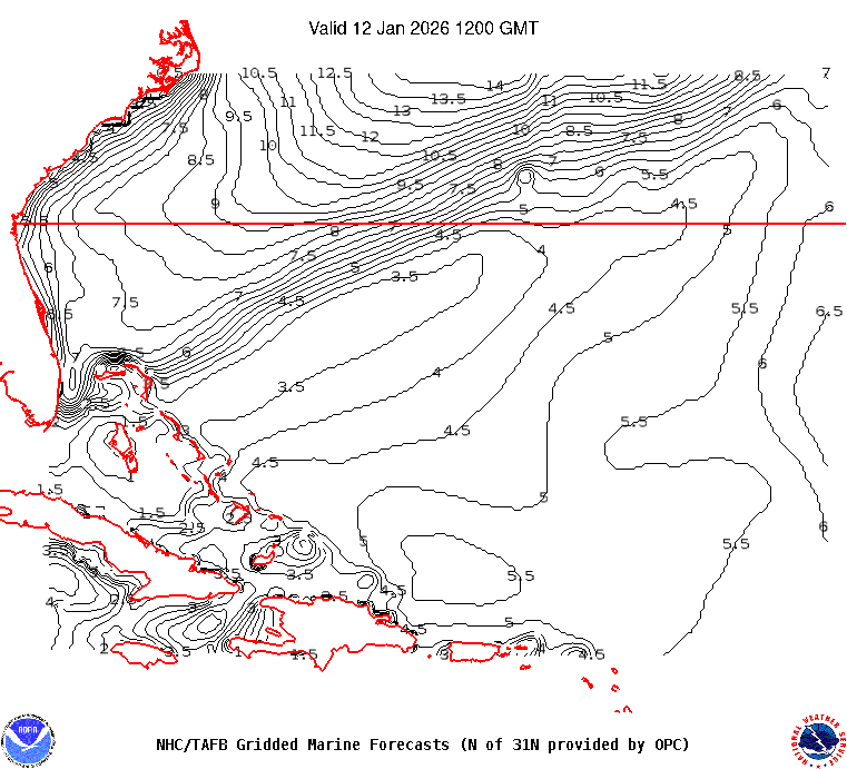
This map illustrates sea height contour (in feet) for the near shore Atlantic Ocean east of Florida:

 ______________________________________________________________________________________________________
Sea surface temps in the GOMEX and western Caribbean Sea.
Watch this GOES loop for lightning signatures that indicate intense convection.
______________________________________________________________________________________________________
The NHC Atlantic Tropical Weather Discussion and the tropical western Atlantic satellite loop are good tools to monitor the Atlantic basin for activity. Good links (updated regularly) to excellent private websites with forecast discussions monitoring tropical and non-tropical weather impacting Florida and the eastern US: Central Florida Hurricane Center and WeatherBELL
Here is a link to the impact hurricane activity has on our coast: Florida beaches face sand shortage
El Nino Southern Oscillation (ENSO) Discussion