FLORIDA EAST COAST MARINE WEATHER (edited by Dean)
A series of re-enforcing cold fronts will sweep across the area during the first 2 weeks in January, pushed by cold Canadian (then Arctic) high pressure areas producing moderate NW (strong at times) northwest winds. Waves will trend smaller through the period, with only minor upticks in angled north swell possible behind each of the progressively colder fronts that push through Florida every 3 days or so. The main hope for some improvement in size will come if a low pressure area can form in the northern Gulf of Mexico, track E/NE then emerge off the southeast coast far enough offshore while intensifying into a winter storm. Latest model run indicated the possibility of a quick-hitting, decent-sized moderate to long period N/NE swell from such a set up in about a week for Saturday/Sunday (January 11-12th). Bottom line, it’s gonna be so damn cold and small through much of month that it won’t matter unless the surf picks up in size.
DEAN’S 7-DAY SURF FORECAST
THURSDAY: A seasonally cool morning (mid/upper 40’sF) with wind light NW early, then a seasonally cool day (low/mid 60’sF) with wind becoming north 8-16 mph with waves 1-occ 1.5′ (+/-0.5′) in close period (5-6 sec) NNE swell with a very minor background long period (10 sec) ENE swell.
FRIDAY: A chilly morning in the mid 40’sF with wind lightest from the west early, then wind WNW 7-16 mph with waves 1′ (+/-0.5′) in close to moderate period (6-7 sec) N/NE swell. Cold air will ride in on the increasing NW wind overnight, setting up a very cold day Saturday.
SATURDAY(4Jan): A cold morning (low 40’sF) with a brrrrisk wind from the NW 10-17 mph in the morning (wind chill in the mid 30’sF) with waves around 1-1.5′ (+ south) in mixed period (6-occ 13 sec) angled “humps on the horizon” NNW/NE swell with more of the offshore swell wrapping in during the afternoon.
SUNDAY: Wind NW/N easing to 5-13 mph with waves 1-occ/inc 1.5′ (+south am) in moderate period (7-8 sec) NE swell, diminishing in the afternoon.
MONDAY: Following a cool morning (around 50F) with wind starting out S/SSW 8-15 mph early, then a mild day (near 70F) with wind increasing from the SW 14-22 mph during the afternoon with waves occ 1′ (+/-0.5′) in mixed period (8-occ 10 sec) N/NE swell.
TUESDAY(7Jan): Downright cold in the morning (upper 30’sF) with wind clocking NW/NNW 10-20 mph and waves starting out around 1′, up some during the afternoon to 1-1.5′ (+ south) in angled “humps on the horizon” close period (5-6 sec) north swell. High temps will not get out of the mid-50’sF north of the Cape, and the strong wind will make it feel even colder.
WEDNESDAY: A cold morning (mid 30’sF) with wind NW early, then a cold day (upper 50’sF) with wind clocking north 8-14 mph with waves 1-occ 1.5′ (+/-0.5′) in moderate period (7 sec) N/NE swell.
THURSDAY: Another chilly morning (around 40F) with wind calm to light offshore, then a sunny/cool day with wind variable to onshore in the afternoon and waves around 1′ (+/-0.5′) in moderate to occ long period (8-occ 10 sec) NE swell
Huge surf in the eastern Pacific Ocean this week devested Peru… check out the clean up set in NW Peru that apparently was generated by a tsunami
For Sale: Like new hand-shaped (Hall of Fame Shaper Bernie Crouch) 6’9″ x 21.75″ x 2.75″ Mad Dog epoxy quad, diamond tail, channel bottom, full deck pads, full nose guard, $525 w/o fins, $625 with Rob Machado quad set. Versatile board for Florida surf conditions- high volume carve-allistic fun shape for a 170-220 lb “big boy”. The old knees ain’t what they used to be… so downsizing stand-up quiver to make room for another knee board. Text Dean @ 321-289-5009 for pics.
Ocean conditions monitoring notes/links: With the outbreak of cold northerly wind behind the recent cold fronts, a good winter-time gauge of fluctuating surf temperatures along the NE Florida coast may be found from upstream readings at the closer to the shore Fernandina Beach buoy. This buoy dropped below 60F around Christmas and will drop down to the mid-50’sF by mid-January given the progression of strong cold fronts, and could stay below 60F into early February. It would not be a total surprise to see it bottom out around 52F(+/-2F) this winter.
Use the local buoy 40 miles offshore from St. Augustine to determine swell arrival in a matter of several hours. Further ESE out in the Atlantic, the NE Bahamas buoy #41047 and buoy #41046 east of the central Bahamas broke free of their moorings during the flurry of tropical activity this hurricane season and are currently adrift in the Atlantic. Until these buoys are restored, buoy # 41049 300 nautical miles SSE of Bermuda may be monitored for fetch/duration of easterly swell to estimate the wave potential a day or two ahead.
Unfortunately, buoy #41002 225 nautical miles south of Hatteras went adrift on December 30th after remaining moored to the sea floor through hurricane season, so our indicator (about a day in advance) for increases in NE/ENE ground swell over the offshore waters from low pressure systems pushing off the mid-Atlantic coast for the rest of the winter is now gone, leaving us blind to harbinger data for swell from the north central Atlantic. The Edisto buoy 41 nautical miles southeast of Charleston and the Grays Reef buoy 40 nautical miles southeast of Savannah are good indicators for the potential (around half of a day or so) arrival of N/NE wind and wind swell behind cold fronts pushing down and off the South Carolina and Georgia coasts, then eventually into northeast Florida.
7-10 DAY WEATHER OUTLOOK (winter weather discussion)
Generally mild weather with decent surf will be the rule through the end of the year. Wind will ease, then clock offshore through New Years Eve ahead of another cold front, allowing for cleaner conditions. On New Years Day, the strong/dry cold front will push through, and much colder air will surge into Florida overnight. The next 2 weeks in January will see several strong/dry cold fronts push through, with moderate to strong NW winds making for a prolonged period of cold to potentially bitter cold weather and generally small surf. A hard freeze will be possible January 10th following a strong cold front pushed by an Arctic air mass, dropping surf temps north of the Cape below 60F (possibly bottoming out in the mid/upper 50’sF). Guess us warm Florida water surfers should’ve booked a trip to the islands, or the powered ski slopes from the Appalachians north to Vermont… so stay tuned!
NWS Coastal Waters/Weather Forecast Links
St. Augustine to Flagler Beach
NWS Jacksonville Coastal Forecast
New Detailed NWS Wave Forecast handout
NOAA upgrading nearshore wave prediction
7-day St. Augustine buoy sea height forecast (primary swell).
Florida Coastal Forecast Map (click on zone)
Marine Page for SE Georgia/NE Florida
_________________________________________________________________________________________
This graph illustrates the 14-day forecast for primary swell height and period for the St. Augustine offshore buoy:
St Augustine buoy 14-day forecast
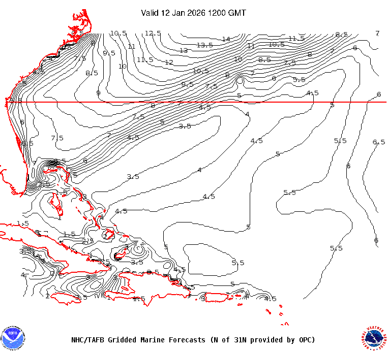
This map illustrates sea height contour (in feet) for the near shore Atlantic Ocean east of Florida:


 ______________________________________________________________________________________________________
Sea surface temps in the GOMEX and western Caribbean Sea.
Watch this GOES loop for lightning signatures that indicate intense convection.
______________________________________________________________________________________________________
The NHC Atlantic Tropical Weather Discussion and the tropical western Atlantic satellite loop are good tools to monitor the Atlantic basin for activity. Good links (updated regularly) to excellent private websites with forecast discussions monitoring tropical and non-tropical weather impacting Florida and the eastern US: Central Florida Hurricane Center and WeatherBELL
Here is a link to the impact hurricane activity has on our coast: Florida beaches face sand shortage
El Nino Southern Oscillation (ENSO) Discussion

